"Were whales stranded and killed in New Zealand the first victims of Seabed 2030 program?"
38 PILOT WHALES DEAD, HAAST, SOUTH ISLAND NEW ZEALAND
MULTI-BEAM SONAR TECHNOLOGY


"AUTONOMOUS MULTIBEAM SONAR BARGE...
...would be controlled and transmit data through telepresence and could become platform for many oceanographic and atmospheric measurements telepresence and could become platform for many oceanographic and atmospheric measurements and maintain long-endurance at sea with relatively little cost and maintain long-endurance at sea with relatively little cost."
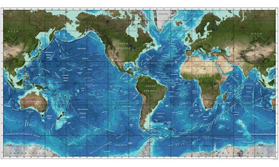
"The oceans cover seventy percent of the Earth’s surface, yet more than eighty percent of our oceans are unmapped, unobserved, and unexplored. Only about 10% have been mapped using modern technology. Another approximately 5% were mapped using lead lines and explosives, which provides only a general sense of the area. The global maps of the seafloor that look comprehensive on Google Earth and other projections are actually only capable of resolving features larger than five kilometers, and are frequently hundreds or even thousands of metres in error. That means entire seamounts, channels, and other geologic structures, their corresponding ecosystems, and potential resources go undiscovered for most of the Earth"
"It means that billions of dollars of offshore wind capacity, fossil fuels and deep-sea mining cannot be exploited, and the ecosystems that may be affected by these activities cannot be protected because they are currently unknown."
"While incremental improvements are ongoing, the challenge of mapping the world ocean will benefit greatly from new technological breakthroughs, and thus the Seabed 2030 Project will explore, initially through workshops and collaboration with industry, new approaches to seafloor mapping that would particularly enhance efficiency and coverage. Among the new technologies to be examined will be the possibility of low-powered echo sounders deployed on gliders or ARGO floats, the possibility of fleets of long-range AUVs equipped with interferometric swath sonars, and autonomous surface barges or sailing vessels capable of long-duration, ocean-wide transits (Figure 10). These autonomous platforms would be controlled from shore and transmit data back to shore via satellite communication links allowing 24/7 global operation with minimal human supervision. This concept becomes particularly important as we envision thousands of hours of data collection in remote areas of the world oceans where crewed vessels would be particularly inefficient given the need for long transits to accommodate crew changes and the potential monotony of long data collection campaigns."
https://www.researchgate.net/publication/323087253_The_Nippon_Foundation-GEBCO_Seabed_2030_Project_The_Quest_to_See_the_World's_Oceans_Completely_Mapped_by_2030
An independent scientific review panel has concluded that the mass stranding of approximately 100 melon-headed whales in the Loza Lagoon system in northwest Madagascar in 2008 was primarily triggered by acoustic stimuli, more specifically, a multi-beam echosounder system operated by a survey vessel contracted by ExxonMobil Exploration and Production (Northern Madagascar) Limited.
https://www.perthnow.com.au/news/environment/whales-still-washing-ashore-at-hamelin-bay-after-mass-stranding-ng-b88796927z
http://www.doc.govt.nz/news/issues/whale-stranding-near-haast/
https://iwc.int/2008-mass-stranding-in-madagascar
http://www.staradvertiser.com/2018/04/02/breaking-news/hawaii-humpback-whale-counts-plunge-in-march/
ANTHROPOGENIC ACOUSTIC WARFARE ON CETACEANS
"The noise environment is so atrocious in their habitats that they can’t hear each other up to half the time."
http://www.resilience.org/stories/2016-04-04/how-ocean-noise-pollution-wreaks-havoc-on-marine-life/
https://dosits.org/people-and-sound/history-of-underwater-acoustics/the-cold-war-history-of-the-sound-surveillance-system-sosus/
"This acoustic pollution has not yet been fully explored by science, still less explained to the public...The more insidious and acute sounds come from ocean exploration for oil and gas, which is accomplished by setting off huge explosions — it used to be dynamite, and now it is seismic air guns...The sound is six or seven orders of magnitude louder than the loudest ship sounds. It is so loud that when someone is surveying off northern Brazil, I can hear that explosion on a small piece of instrumentation that I deploy 60 miles off the coast of Virginia..."
Unfortunately, Dr. Clark has for some reason totally omitted one of the MAJOR SOURCES OF ANTHROPOGENIC NOISE in the global ocean: the summation of all SONAR SYSTEMS in use on each of the tens of millions of commercial, recreational and military vessels. Naval mid and low-frequency sonars are so powerful that they have been described as having 'a kill zone the size of Texas.'
"The source level of this sonar is 240 decibels (equivalent to the intensity of a Saturn rocket). But, because low frequency underwater sound can travel hundreds of miles with little loss of power, it will actually create a "kill zone" several hundred miles in diameter. NATO naval exercises using low frequency sonar conducted off Greece in 1996 killed whales that were more than 100 km away. In the final EIS for its sonar system, the Navy admits that an intensity of 160 decibels (a lethal level) will be felt several hundred miles away from the source. This will create a "Kill Zone" the size of Texas.
The Navy says it wants to deploy this sonar in 80% of the world's oceans..."
THIS INFORMATION IS FROM 2002...THE SITUATION HAS ONLY WORSENED BY ORDERS OF MAGNITUDE


